Lake Travis Hits Full Capacity for the First Time Since 2019
Lake Travis reaches full capacity for the first time in seven years, signaling a major victory for Central Texas water supplies and recreation.
Editorial disclaimer: Opinions and analysis on Keep TX Red are editorial content — not statements of fact. See our editorial standards.
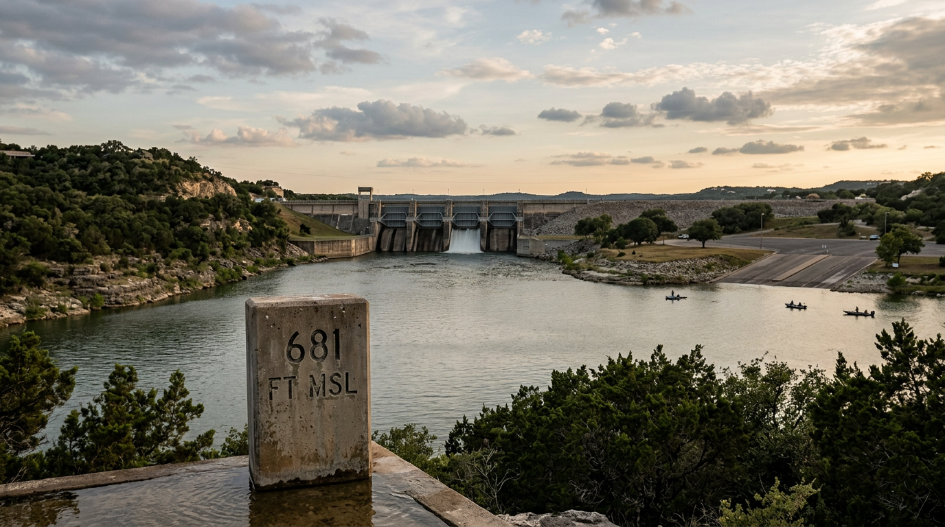
For the first time in nearly seven calendar years, Lake Travis has reached its full capacity level, marking a historic turnaround for one of Central Texas’s most vital reservoirs. Since 2019, the lake has been plagued by prolonged drought conditions, receding shorelines, and the closure of multiple public boat ramps due to dangerously low water levels. As of July 2026, the water surface has finally touched the 681-foot mean sea level (msl) mark, which the Lower Colorado River Authority (LCRA) defines as the official full pool for the reservoir. This milestone comes after a series of concentrated weather patterns that funneled significant runoff into the Highland Lakes chain, effectively erasing years of hydrologic deficit within a relatively short period. Historically, Lake Travis has served as a primary flood control and water supply reservoir for the Austin metropolitan area and Southeast Texas rice farmers downstream. The last time the lake was at this level was during a brief period in 2019, following a massive flood event in late 2018. Since that time, residents and business owners along the shoreline have watched as the lake dropped to levels reminiscent of the record-breaking drought of 2011. The current restoration of water levels is not merely a cosmetic change for the landscape; it represents a replenishment of the regional water bank that millions of Texans rely on for daily consumption, industrial use, and agricultural irrigation. The sight of water touching the limestone bluffs and submerging islands that had been dry for years has drawn crowds of spectators to Mansfield Dam to witness the transformation of the Colorado River valley firsthand.
Texas relevance
The stabilization of Lake Travis is a critical development for the Austin and Central Texas corridor. For years, the dipping lake levels forced the Travis County Parks department and the LCRA to shutter public access points, hurting the local tourism economy in cities like Lakeway, Lago Vista, and Volente. With the lake back at full capacity, the surrounding communities can expect a surge in economic activity as marinas regain full functionality and property values stabilize along the waterfront. Furthermore, the fullness of Lake Travis serves as a crucial insurance policy for the City of Austin’s municipal water supply, ensuring that the region has a sufficient buffer against the inevitable return of arid conditions in the Texas summer heat.
The Journey from Drought to Full Pool
The timeline of Lake Travis over the last half-decade has been one of stark contrasts. Following the 2019 peak, the basin entered a period of diminished rainfall and high evaporation rates. By 2023 and 2024, many parts of the lake had turned into grassy valleys, with the pedestal at the iconic Oasis restaurant overlooking a riverbed rather than a vast lake. These low levels were not just an eyesore; they posed significant navigation hazards, as hidden trees and rock formations became submerged just inches below the surface as the water receded.
The turnaround began with a shift in the Pacific oscillation patterns, which redirected storm tracks across the Edwards Plateau. These storms hit the 'sweet spot' for the Highland Lakes, dropping heavy rains in the Llano and Pedernales River watersheds. Because the ground was already saturated from previous light rains, the resulting runoff was highly efficient, filling Lake Buchanan first and then cascading down through Inks, LBJ, and Marble Falls before finally accumulating in the massive basin of Lake Travis. This sequential filling is the intended design of the Highland Lakes system, which is managed to prioritize storage in the two largest 'bucket' reservoirs: Buchanan and Travis.
Economic Implications for Waterfront Businesses
Marina operators and local businesses in Travis County are bracing for a record-breaking summer season now that the water has returned. During the low-water years, several marinas were forced to physically move their docks hundreds of feet further into the main channel to keep boats afloat, a costly and labor-intensive process. Many restaurants that rely on boat-in traffic saw their customer bases dwindle when docks became inaccessible. The return to 681 feet means that every dock in the basin is now functional, providing a massive boost to the local tax base.
Beyond the hospitality sector, the full lake impacts the real estate market. Waterfront properties that were previously looking at mudflats have seen a renewed interest from buyers, as 'waterfront' once again means proximity to the lake surface. This surge in interest is expected to increase property tax revenues for local school districts and municipal governments, which had previously faced stagnant valuations on distressed lakeside parcels. The ripple effect of a full lake extends well beyond the shore, influencing the entire Central Texas economy.
Managing the Overflow: LCRA Operations
With the lake at 100% capacity, the Lower Colorado River Authority (LCRA) enters a different phase of management. Their focus shifts from conservation to flood mitigation. While 681 feet is 'full' for conservation purposes, the lake is designed to hold much more during flood events, with a maximum flood pool capacity that extends up to 714 feet. Engineers at Mansfield Dam are now closely monitoring upstream gauges to determine if and when floodgates must be opened to pass excess water safely downstream toward the Gulf of Mexico.
The process of 'moving water' is a delicate balance of protecting downstream communities from sudden surges while maintaining the maximum possible storage in the reservoir. Residents in Bastrop and Smithville are particularly sensitive to these operations, as large releases from Mansfield can cause the Colorado River to swell quickly. The current management strategy is to hold the lake at its current level for as long as possible to maximize water availability for the next dry spell, while remaining ready to utilize the spillway if another major rain event occurs in the Hill Country.
Environmental and Ecological Benefits
The refill of Lake Travis provides a significant boost to the local aquatic ecosystem. Low water levels often lead to increased water temperatures and decreased dissolved oxygen, which can stress fish populations like largemouth bass and striped bass. The inundation of the dry shoreline has covered years of terrestrial plant growth, creating 'new' underwater habitats. These submerged bushes and grasses provide perfect spawning grounds and cover for baitfish, which in turn supports a healthier predator fish population.
Additionally, the rising water helps naturally manage invasive species. In some areas, the fluctuating levels help control certain types of undesirable vegetation that thrive in stagnant, shallow water. The influx of fresh water also helps dilute any concentrated pollutants or runoff that may have accumulated during the stagnant drought period, improving the overall water quality for the municipal intake pipes that serve the Lakeway and Austin areas.
Public Access and Safety Warning
While the full lake is a welcome sight, officials are issuing warnings to boaters who may have grown accustomed to the low-water conditions. New underwater obstructions that haven't been submerged in years—such as debris, fallen trees, and abandoned equipment on the former shoreline—may now be lurking just below the surface. The LCRA and the Travis County Sheriff's Office are encouraging boaters to exercise caution and utilize updated GPS maps, as the channel has changed significantly since the last time the water was this high.
All public boat ramps in the Travis County system, including those at Pace Bend and Arkansas Bend, are expected to be fully reopened within days. This is a dramatic change from just six months ago, when only a few private deep-water ramps were operational. The influx of boaters is expected to bring heavy traffic to Ranch Road 620 and Highway 71, and authorities are planning increased patrols to manage the crowds and ensure safety both on the water and on the surrounding roads.
Analysis
While the return to a full pool is a celebratory moment, it serves as a reminder of the 'flash' nature of Texas hydrology. The state often swings between extremes of multi-year droughts and sudden, massive recharge events. Critics of current water management policies note that while the lake is full today, the rapid population growth in the Austin-Round Rock-Georgetown MSA is putting unprecedented pressure on the Colorado River basin. Policymakers will likely use this moment of abundance to continue pushing for the development of the Arbuckle Reservoir downstream, which is intended to reduce the demand on Lake Travis by providing an alternative storage solution for agricultural needs. For now, the focus remains on the immediate relief provided to the local ecosystem and the residential recreation market.
Source attribution
This story was reported using a public release from the r/texas. Keep TX Red rewrote the coverage independently and links to the official statement for verification.
Frequently Asked Questions
- What is the official 'full' level for Lake Travis?
- Lake Travis is considered full at 681 feet above mean sea level (msl). While the dam can hold water up to higher elevations for flood control, 681 is the target level for water conservation storage.
- Why did it take so long for the lake to refill?
- Central Texas underwent a prolonged period of drought and below-average rainfall beginning in late 2019. Because Lake Travis is a massive reservoir, it requires significant, sustained runoff from its feeder rivers—the Llano, Pedernales, and the upper Colorado—to significantly raise its levels.
- Are there any floodgates open at Mansfield Dam?
- Currently, the LCRA monitors the level closely. Gates are typically only opened if the lake exceeds the 681-foot mark and significant additional inflow is expected from upstream to prevent the water from reaching unsafe flood levels.
- Can I use any boat ramp now?
- With the lake at 681 feet, almost all public and private boat ramps on Lake Travis should be operational. Users should check with Travis County Parks or the LCRA website for specific ramp statuses and any potential debris warnings.
Official Sources
Take the next step
Browse the Newsroom →Read more about Keep Texas Red → Our full guide to what Keep Texas Red means and why Texans support it.
Related Articles



Get Texas updates delivered weekly.
Independent Texas reporting on politics, policy, and daily life. One email a week. Unsubscribe anytime.
Keep TX Red Newsroom
The Keep Texas Red Editorial Staff produces nonpartisan explainers, policy breakdowns, and educational resources to help Texans understand how their government works. All content is reviewed for accuracy and updated regularly.
About Keep TX Red →