Deadly Hill Country Flash Flooding Moves West as Texas Faces Continuing Rain Risks
Tragedy strikes the Texas Hill Country as severe flooding turns fatal. Western regions now face a heightened threat of rising waters through Friday.
Editorial disclaimer: Opinions and analysis on Keep TX Red are editorial content — not statements of fact. See our editorial standards.
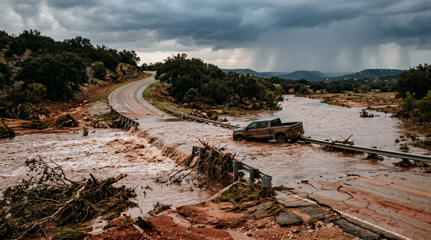
Recent atmospheric instability combined with a stalled frontal boundary has triggered a catastrophic flooding event across the heart of the Lone Star State. Starting late Wednesday and stretching into Thursday morning, the Texas Hill Country bore the brunt of intense precipitation, which resulted in at least two confirmed fatalities. These tragedies occurred as rapidly rising waters overwhelmed local low-water crossings, a perennial danger in the undulating limestone terrain of Central Texas. Emergency crews across several counties were pushed to their limits performing swift-water rescues as streets transformed into rivers within minutes. Historically, the Hill Country is known as 'Flash Flood Alley' due to its thin soil and rocky surfaces that prevent absorption, leading to immediate runoff into gullies and tributaries. As the initial storm cell began to dissipate over the Edwards Plateau, the threat began migrating toward the more arid regions of West Texas. Meteorologists are monitoring a system that is pulling moisture from the Gulf of Mexico, potentially dumping several inches of rain on ground that is not accustomed to such high volumes. This transition poses a unique set of challenges for infrastructure in Western counties where drainage systems are often designed for lighter, more sporadic events. The death toll in the Hill Country serves as a somber reminder of the power of moving water, especially during nighttime hours when visibility is severely limited. State officials are urging residents to remain vigilant as the weather pattern remains unsettled through the end of the week.
Texas relevance
This weather event impacts a massive geographical swathe of Texas, specifically targeting the Hill Country and the Permian Basin regions. In Texas, flash flooding remains one of the top weather-related killers, largely because of the state's vast network of low-water crossings. Cities like San Angelo, Abilene, and the surrounding rural communities are now on high alert as the water moves toward West Texas. For Texans, this highlights the critical importance of programs like TxDOT's 'Turn Around Don't Drown' campaign, which was pioneered in the state precisely because of the localized meteorological hazards found between the Balcones Escarpment and the High Plains. Every major flooding event in this corridor directly impacts the state's agriculture, transportation, and public safety resources.
The Evolution of Flash Flood Alley
The central portion of Texas, often referred to as Flash Flood Alley, has earned its reputation through decades of extreme weather events. The geographic transition from the Gulf Coastal Plain to the Balcones Escarpment forces air upward, frequently creating intense localized storms. Because the Hill Country sits on a bed of solid limestone with very little topsoil, even two inches of rain can result in total runoff, filling dry creek beds with walls of water in seconds.
In the most recent event, the rainfall was particularly concentrated, catching many motorists off guard during the early morning hours. This specific region of Texas has seen some of the most historic floods in U.S. history, and the current fatalities underscore that despite better technology, the terrain remains inherently dangerous. Local law enforcement noted that the speed at which the water rose left little time for traditional evacuation procedures in low-lying areas.
Infrastructure damage is currently being assessed, but preliminary reports indicate several secondary roads have been washed out or covered in debris. State troopers have been deployed to assist local sheriffs in closing high-risk intersections. The immediate priority for the state is ensuring that the casualty count does not rise as the system moves into areas with even sparser emergency coverage.
Transitioning to the West Texas Plains
As the storm system marches toward West Texas, it enters a region where the soil is often more permeable but the drainage infrastructure is less frequent. In areas around San Angelo and Midland, the concern shifts toward urban flooding and the impact on the energy sector. Heavy rains can turn caliche roads into impassable mud pits, halting movement in oil fields and affecting the local economy.
The West Texas landscape is characterized by wide, flat vistas that can hide the depth of standing water. Meteorologists are particularly concerned about 'training' storms, where multiple cells follow the same path, leading to localized totals that exceed monthly averages in a single afternoon. This poses a risk to livestock and rural residents who may find themselves isolated if bridge approaches are compromised.
Community leaders in the West are using social media and local radio to disseminate real-time warnings. Unlike the Hill Country, where water moves fast through canyons, West Texas flooding can often result in long-term standing water that takes days to recede. This requires a different logistical approach for emergency services, focusing on long-distance high-water vehicles and aerial reconnaissance.
Fatalities and the Danger of Low-Water Crossings
The two confirmed deaths in the Hill Country are a stark reminder of why Texas leads the nation in flood-related vehicle fatalities. Most victims of flash floods are not those caught in their homes, but individuals attempting to drive through water-covered roads. It only takes twelve inches of rushing water to carry away a small car, and two feet can sweep away large SUVs and trucks.
Investigators believe the victims were caught in the darkness of Thursday morning when it is nearly impossible to distinguish between a wet road and a submerged bridge. Throughout the state, there are over 10,000 low-water crossings, many of which lack automated gates or lighting. This incident will likely pressure local county commissioners to seek state grants for bridge elevation projects.
The emotional toll on these small communities is immense. In rural Texas, volunteer fire departments are usually the first on the scene, and these responders are often neighbors of those they are trying to save. The psychological impact on first responders during these mass-water events is a growing concern for state health agencies who provide support following natural disasters.
Statewide Emergency Response Coordination
The Texas Division of Emergency Management (TDEM) has activated several task forces to monitor the situation as it evolves. This coordination involves the Texas Parks and Wildlife Department, which provides specialized boat crews, and the Texas Military Department. The goal is to preposition assets ahead of the storm's path in West Texas to ensure rapid response times should more people become stranded.
Governor Abbott's office has been briefed on the casualties and the projected path of the inclement weather. While a formal disaster declaration is pending the final damage assessment, the state is prepared to offer assistance to affected counties. This centralized approach allows resources from less-affected areas, like North Texas, to move southward and westward as needed.
Technological advancements like the 'TexasFlood.org' portal are being utilized to provide the public with live data on river stages and road closures. These tools are critical for commerical trucking, which is a backbone of the Texas economy. Ensuring that regional freight routes remain open or have clearly marked detours is a high priority for the Texas Department of Transportation.
Projected Weather Outlook and Community Preparation
The forecast through Friday evening suggests that the atmospheric moisture will not fully clear until Saturday. This means the risk for 'flash' events remains high even if the sun peek through the clouds periodically. Ground saturation is the primary concern; once the soil is full, any additional rainfall immediately becomes runoff. Residents are encouraged empty their rain gauges often and report significant totals to the National Weather Service.
For those living in West Texas, the advice is to stock up on essentials and avoid unnecessary travel until the system passes. Power outages are possible if high winds accompany the thunderstorms, adding another layer of risk to the flooding. Checking on elderly neighbors and ensuring pets are secured in high-elevation areas are standard protocols during these alerts.
Long-term, this event serves as a case study for Texas urban planners. As more people move into the Hill Country and the West Texas corridors, the amount of impervious cover (like concrete) increases, which only exacerbates flood risks. Maintaining green space and natural drainage basins is becoming a pivotal part of Texas land-use policy to prevent future tragedies like the ones seen this week.
Analysis
While rainfall is often a blessing for the drought-prone regions of West Texas, the current intensity represents a significant public safety risk rather than a beneficial moisture event. The tragic loss of life in the Hill Country illustrates a recurring problem in Texas infrastructure: the difficulty of upgrading thousands of rural low-water crossings to modern safety standards. From a policy perspective, this will likely reignite discussions regarding the State Water Plan and the allocation of disaster mitigation funds for inland flooding. As the weather pattern shifts West, the focus moves from immediate rescue to long-term prevention. The state’s ability to coordinate between local emergency management and the National Weather Service is being tested, showing that even with advanced warning, the topographical reality of 'Flash Flood Alley' remains a deadly challenge for any administration.
Source attribution
This story was reported using a public release from the Texas Standard. Keep TX Red rewrote the coverage independently and links to the official statement for verification.
Frequently Asked Questions
- What exactly is Flash Flood Alley in Texas?
- Flash Flood Alley is a region in Central Texas, specifically along the Balcones Escarpment, that is prone to some of the highest rainfall rates and most rapid flooding in the world. The combination of steep hills and rocky soil means water cannot soak into the ground, leading to fast-moving floods in rivers like the Llano, Guadalupe, and Colorado.
- Why are low-water crossings so dangerous?
- Low-water crossings are dangerous because the road surface is intentionally designed to sit low, allowing water to flow over it during rain. However, the force of even shallow-looking water can be enough to lift a vehicle off the pavement and sweep it downstream, where it may flip or become trapped against trees and debris.
- What should West Texas residents do differently during this flood warning?
- Residents in West Texas should monitor local weather alerts closely, as their drainage systems may not handle rapid rainfall as efficiently as coastal areas. They should avoid driving on unpaved roads which can turn into sludge and ensure that livestock are moved to higher ground before the heaviest rains begin.
- How can I check road closures officially?
- The best resource for checking road closures in Texas is DriveTexas.org, which is maintained by the Texas Department of Transportation (TxDOT). It provides real-time information on flooding, construction, and damage-related closures across the state's highway system.
Official Sources
Take the next step
Browse the Newsroom →Read more about Keep Texas Red → Our full guide to what Keep Texas Red means and why Texans support it.
Related Articles



Get Texas updates delivered weekly.
Independent Texas reporting on politics, policy, and daily life. One email a week. Unsubscribe anytime.
Keep TX Red Newsroom
The Keep Texas Red Editorial Staff produces nonpartisan explainers, policy breakdowns, and educational resources to help Texans understand how their government works. All content is reviewed for accuracy and updated regularly.
About Keep TX Red →