Kerr County Flash Flood Emergency Sparks Shelters and Road Closures
Kerrville residents under shelter-in-place as record rainfall triggers emergency flash flood warnings and memories of the tragic 2025 floods.
Editorial disclaimer: Opinions and analysis on Keep TX Red are editorial content — not statements of fact. See our editorial standards.
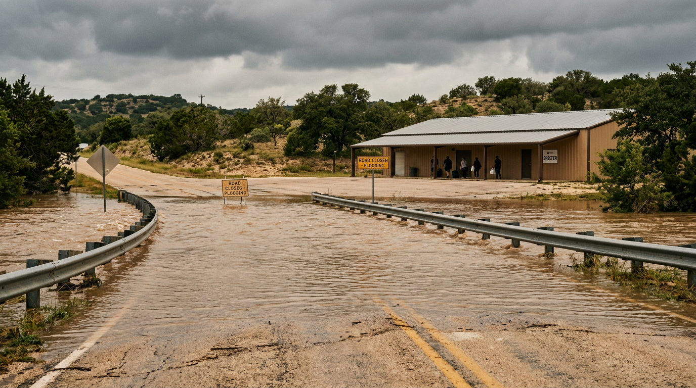
Heavy rainfall across the Texas Hill Country has triggered a severe flash flood emergency for Kerr County, prompting local officials to issue immediate shelter-in-place orders for the city of Kerrville. The weather event began in the early morning hours of July 16, 2026, as slow-moving storm cells stalled over the Guadalupe River basin, saturating the ground and causing rapid rises in local creeks and tributaries. This alert represents the highest level of flood warning issued by the National Weather Service, reserved for life-threatening situations where massive water flow is imminent or occurring in populated areas. Local emergency management teams have been deployed to monitor high-water crossings and facilitate potential water rescues as runoff continues to accumulate. Historically, the region has faced significant hydrological challenges; this latest event comes almost exactly one year after the devastating floods of July 2025 that forever changed the landscape of the area. Public safety departments are urging all residents to avoid travel as many secondary roads and major thoroughfares are currently impassable due to rising waters.
Texas relevance
Kerr County serves as a vital component of the Texas Hill Country economy and natural landscape, making this flood emergency a matter of significant regional concern. The Guadalupe River, which flows through the heart of Kerrville, is a major water source and recreational artery for the state of Texas, and its rapid cresting impacts everything from local agriculture to tourism infrastructure. Historically, Hill Country flash floods are among the deadliest in North America due to the thin soil and limestone topography which prevents water absorption, leading to 'wall of water' events that can overwhelm culverts and bridges in minutes. This specific event tests the resilience of newly implemented drainage systems and emergency response protocols developed by the state following the 2025 disaster, providing a critical evaluation of Texas's infrastructure preparedness.
The Evolution of the July 16 Storm System
The current weather crisis began as a localized low-pressure system interacted with high moisture levels coming off the Gulf of Mexico. Unlike typical summer showers that pass quickly, these systems locked in place over the rugged terrain of Kerr County. The resulting downpour dropped several inches of rain in a timeframe of less than three hours, overwhelming the natural drainage capacity of the region.
Meteorologists noted that the soil in the Hill Country was already somewhat saturated from previous light rains, which exacerbated the runoff. As the Guadalupe River approached flood stage, the National Weather Service upgraded the status from a standard warning to a Flash Flood Emergency. This distinction is critical as it signals a heightened risk to life and property, requiring residents to take immediate protective actions rather than merely monitoring the news.
By mid-morning, the focus shifted from rain accumulation to water movement. The steep slopes of the Edwards Plateau directed water into narrow canyons and creek beds, leading to rapid rises downstream. Authorities report that the intensity of the water flow has made some traditional monitoring equipment difficult to access, requiring the use of remote sensors and aerial drones to track the surge's progress through the county.
Shelter-in-Place Protocols and Roadway Closures
The city of Kerrville took the preemptive step of issuing a shelter-in-place alert to prevent citizens from entering the dangerous roadway conditions. Emergency services communicated through text alerts, sirens, and social media, advising that the safest place during this surge is the upper floors of sturdy buildings. Traditional evacuation routes were deemed too hazardous as several key bridges were reported to have water flowing over the decks.
Law enforcement agencies, including the Kerr County Sheriff's Office and local police, have established blockades at known high-water crossings. Historically, a majority of flood-related fatalities in Texas occur within vehicles, often when drivers underestimate the depth or velocity of water crossing a road. The 'Turn Around Don't Drown' campaign has been the central message of the day as crews work to ensure no motorists are trapped in the rising tide.
In addition to city streets, major rural highways connecting Kerrville to surrounding towns like Fredericksburg and Comfort have seen significant disruptions. The Texas Department of Transportation (TxDOT) has mobilized teams to assess bridge integrity, though full inspections cannot occur until the water recedes. For now, the priority remains strictly on life safety and keeping the public situated in safe harbor until the immediate threat of cresting water passes.
Comparing the Current Crisis to the 2025 Floods
Community members are understandably shaken as this event mirrors the tragic flooding that occurred just over a year ago in July 2025. During that previous event, record-breaking rainfall led to significant property loss and multiple fatalities, leaving a lasting scar on the local psyche. The current emergency brings back painful memories, but officials note that the communication tools and response times have improved significantly since that time.
Following the 2025 disaster, Kerr County invested in more robust emergency alert systems and better hydrological mapping. These tools allowed for the current shelter-in-place order to be issued much faster than in previous years. While the volume of water is comparable, the proactive stance taken by city leadership aims to ensure that the loss of life remains at zero during this particular weather pattern.
The psychological impact of back-to-back yearly floods cannot be overstated for the residents of the Hill Country. Many small business owners were just finishing renovations from the previous summer's damage when the rains returned this morning. State representatives have already begun discussing the potential for disaster declarations to unlock funding for recovery, though the primary focus remains the ongoing rainfall and the safety of residents still in the path of the water.
Infrastructure Resilience and Future Mitigation
Texas has long struggled with the 'flashy' nature of its river systems, and Kerr County is often the epicenter of these challenges. The existing infrastructure, including culverts and retention ponds, was designed based on historical data that is increasingly being challenged by modern weather extremes. This current emergency will likely serve as a data point for future engineering projects aimed at hardening the Guadalupe River basin against such surges.
Engineers have been observing how newer drainage channels are handling the overflow. In some sections of Kerrville, recent upgrades appear to be diverting water away from residential areas effectively, though the sheer volume of the current downpour is testing the limits of these designs. The state's long-term flood plan involves more than just concrete; it includes natural land management to increase the soil’s ability to hold water.
Looking forward, the debate over Hill Country development will likely intensify. As more impervious surfaces like parking lots and rooftops are built, the speed of runoff increases. This storm serves as a reminder to planners that the balance between economic growth and environmental safety is delicate. The lessons learned from the next 48 hours will be vital for the Texas Legislature as they consider future water and infrastructure budgets.
Safety Recommendations and Emergency Contacts
Residents are reminded that if they are in a low-lying area and water begins to enter their home, they should move to the highest point possible, such as a roof, but only as a last resort. It is essential to avoid attics unless there is an outlet to the roof to avoid becoming trapped by rising water. For those in safe locations, the best course of action is to stay put and keep cell phones charged while monitoring local news outlets for updates.
Emergency services are currently prioritized for life-saving rescues. Citizens are asked not to call 911 for general information or power outage reports to keep lines open for those in immediate peril. Local shelters are being prepared by the Red Cross and other community partners, though they will only become accessible once the main transit routes are cleared of standing water.
As the rain begins to taper off in some areas, the danger persists due to upstream runoff. Even if it is not raining in a specific neighborhood, the 'flash' nature of these floods means a surge can arrive from miles away without warning. Public safety officials will provide a 'clear' signal only after water levels have stabilized and debris has been cleared from major intersections.
Analysis
The recurrence of catastrophic flooding in the Kerrville area highlights a persistent challenge for Texas regional planning. While the state has invested heavily in flood mitigation through the Texas Water Development Board, the sheer volume of water delivered by stationary storm cells often exceeds the capacity of even modern drainage systems. The decision to issue a shelter-in-place order rather than a mass evacuation suggests that local officials have identified the roads themselves as the greatest hazard, prioritizing keeping citizens on high ground rather than risking stalled vehicles in low-lying crossings. The timing of this event, falling during the height of the summer season, also underscores the necessity for Texas residents and visitors to maintain constant weather awareness, as the arid nature of the Hill Country can transition into a delta-like environment in a matter of hours.
Source attribution
This story was reported using a public release from the Texas Standard. Keep TX Red rewrote the coverage independently and links to the official statement for verification.
Frequently Asked Questions
- What is the difference between a Flash Flood Warning and an Emergency?
- A Flash Flood Warning means flooding is imminent or occurring. A Flash Flood Emergency is the highest level of alert, indicating a rare and extremely dangerous situation where catastrophic damage and a threat to life are happening now, requiring immediate action.
- Is it safe to travel through Kerrville right now?
- No. Local authorities have issued a shelter-in-place order. Many roads and bridges are underwater or washed out, and driving in these conditions is the leading cause of flood-related deaths in Texas.
- Where can I find real-time information on road closures in Kerr County?
- Residents should monitor the Kerr County Sheriff's Office social media pages and the TxDOT 'Drive Texas' website for the most up-to-date information on highway status and closures.
Official Sources
Take the next step
Browse the Newsroom →Read more about Keep Texas Red → Our full guide to what Keep Texas Red means and why Texans support it.
Related Articles



Get Texas updates delivered weekly.
Independent Texas reporting on politics, policy, and daily life. One email a week. Unsubscribe anytime.
Keep TX Red Newsroom
The Keep Texas Red Editorial Staff produces nonpartisan explainers, policy breakdowns, and educational resources to help Texans understand how their government works. All content is reviewed for accuracy and updated regularly.
About Keep TX Red →