Severe Flash Flooding Strikes Bandera County as Storms Batter Hill Country
Heavy rain triggers surging floodwaters in Bandera County, prompting safety warnings across the Texas Hill Country.
Editorial disclaimer: Opinions and analysis on Keep TX Red are editorial content — not statements of fact. See our editorial standards.
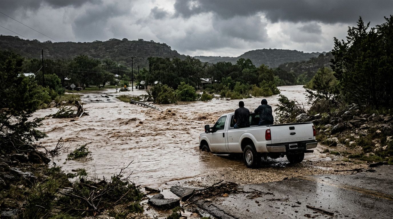
On July 15, 2026, Bandera County experienced significant flash flooding as a powerful storm system moved through the Texas Hill Country. The intense rainfall caused a rapid surge of water through local drainage basins and low-lying areas, turning usually dry creek beds into dangerous torrents. This event follows a pattern of seasonal volatility in the region, where the limestone geography of Central Texas often leads to immediate runoff rather than soil absorption. Historical precedents in the Medina River valley have shown that such surges can occur with very little warning, making current events particularly hazardous for residents and travelers alike. Localized weather patterns in this part of the state are notoriously difficult to predict, often resulting in isolated cells that dump massive quantities of water on specific watersheds while leaving neighboring counties entirely dry. As the runoff accelerates, the structural integrity of local drainage systems is being put to the test. This event is not an isolated incident but a continuation of the hydrological challenges that define life in one of the most flood-prone regions of the United States. The speed at which these waters rise necessitates a high degree of situational awareness from all residents, particularly those living near traditional river paths and low-lying valleys.
Texas relevance
Bandera County serves as a critical drainage point for the Medina River, a major tributary that affects water levels in surrounding areas like San Antonio and Bexar County. For Texans in the Hill Country, these flood events are not just weather reports but direct threats to property and infrastructure. The localized nature of these storms means that while one area may remain dry, a neighboring town like Bandera can face life-threatening water rises within minutes. Understanding the movement of these surge waters is essential for public safety and the maintenance of the hundreds of low-water crossings that dot this specific region of Texas. Furthermore, the economic impact on Texas ranching and agriculture in the Hill Country cannot be understated, as flash floods often destroy fencing, wash away topsoil, and endanger livestock that may be trapped in bottomlands during a sudden rise. Historically, the state has invested heavily in flood mitigation strategies focused on this region, yet the sheer force of nature frequently exceeds the capacity of modern engineering, leaving rural communities to rely on local emergency management and community vigilance.
The Mechanics of Hill Country Flooding
The geology of Bandera County plays a decisive role in why these floods occur so suddenly. The area sits atop the Edwards Plateau, characterized by thin soil layers and hard limestone bedrock. When heavy rains hit, the ground reaches saturation almost instantly, forcing the entirety of the rainfall to flow overland into the nearest creek or river channel. This lack of absorption means that rain falling miles away can contribute to a surge in a different part of the county within a very short timeframe.
This specific hydrological behavior is why the Texas Hill Country is often referred to as 'Flash Flood Alley.' During this latest event, the volume of water was sufficient to create visible surges, which are essentially walls of moving water that can carry debris and vehicles. Local authorities monitor these surge points carefully to determine which roads must be closed to prevent casualties. The unpredictability of these surges is compounded by the fact that they often occur downstream long after the actual rain has stopped falling in that specific location.
In addition to the limestone bedrock, the steep grades found throughout the Bandera area accelerate the velocity of moving water. As the water gathers speed, its destructive power increases exponentially, allowing it to move heavy boulders and large trees. This energy transition from rainfall to kinetic current is the primary cause of damage to low-water crossings and bridges. For residents, this means that even a minor storm can transform into a major disaster if the water is funneled into a narrow limestone canyon.
Impact on Local Infrastructure and Roads
In Bandera County, many primary and secondary roads intersect with natural drainage paths. During the July 15 storm, several of these low-water crossings became impassable as the surge moved through the county. The rapid rise in water levels often puts significant pressure on bridges and culverts that were designed for lower flow rates. This puts a massive strain on the Texas Department of Transportation and local county road crews who must assess these sites in real-time.
Maintenance crews in the region are tasked with inspecting these structures immediately following a surge. The force of the water described in recent reports can displace asphalt and undermine the foundations of rural roads. This creates long-term challenges for the county even after the water recedes, as repair costs for rural infrastructure frequently strain local budgets. In many cases, the damage is not visible until heavy vehicles cross the weakened pavement, leading to secondary hazards.
The destruction of infrastructure also creates logistical hurdles for emergency responders. When a low-water crossing is washed out, it can cut off access to entire residential pockets, requiring the use of high-profile vehicles or aerial support for evacuations. This event highlights the ongoing need for bridge elevation projects across Central Texas to ensure that vital links remain open during the state's increasingly intense storm cycles.
History of the Medina River Surges
The Medina River is a central feature of Bandera, and its history is closely tied to massive flooding events. Past data indicates that the river can rise dozens of feet in a matter of hours under the right conditions. While the current flooding is part of a specific July storm system, it echoes the environmental stressors that have defined the community's relationship with the river for decades. The Medina’s watershed is expansive, collecting water from numerous creeks that unite to create a powerful flow.
Local emergency management plans are largely built around the behavior of the Medina. By observing how water surges through the county today, hydrologists can better predict how future storms will impact downstream reservoirs and residential areas. The current activity serves as a stark reminder of the river's power to reshape the local landscape in a single afternoon. From the Great Flood of 1978 to more recent events, the river remains a dominant and often dangerous force in Central Texas life.
The historical context of these floods helps residents understand the risks of building near the riverbanks. Many properties in Bandera County are subject to strict floodplain regulations because of this history. Despite these regulations, the sheer scale of modern storm events sometimes exceeds the projected hundred-year flood levels, challenging even the most prepared homeowners and business owners in the downtown Bandera area.
Public Safety Measures and Warnings
In response to the surging waters, emergency services have emphasized the 'Turn Around, Don't Drown' protocol. This is particularly relevant in Bandera County, where the depth of water over a road can be deceptive. A surge can increase the depth of a crossing from a few inches to several feet in the time it takes for a motorist to approach the intersection. Authorities have repeatedly warned that the majority of flood-related fatalities occur in vehicles trying to navigate these crossings.
Local officials also utilize automated gauge systems along the river to provide real-time data to the public. These tools are vital for agricultural residents who may need to move livestock or equipment away from the river banks. As the current storm system continues to fluctuate, these warnings remain in effect to prevent the loss of life and property in high-risk zones. The integration of high-tech sensors with traditional sirens and social media alerts has become a cornerstone of the Bandera County safety strategy.
Furthermore, the county has established designated shelter areas and evacuation routes for those in the most vulnerable sectors. During a surge event, the window for safe movement is often less than an hour. Therefore, pre-emptive warnings and public cooperation are essential. The community has a long-standing tradition of neighbor helping neighbor during these crises, but officials urge citizens to let professional swift-water rescue teams handle the most dangerous situations.
Downstream Effects and Regional Outlook
The water moving through Bandera County does not stay localized. It eventually feeds into Medina Lake and continues toward the coastal plains. Significant surges in the Hill Country can lead to improved reservoir levels, which is a silver lining for a state often plagued by drought, but the immediate violence of the flood remains the primary concern. The balance between needing rain for the aquifer and fearing the destruction of the flood is a constant tension for Central Texans.
Meteorological outlooks suggest that the atmospheric conditions causing these heavy rains may persist across Central Texas for several days. This means the soil will stay saturated, making any additional rainfall even more likely to result in immediate runoff. Residents are encouraged to monitor weather updates and be prepared for shifting conditions as the runoff makes its way through the watershed. The cumulative effect of multiple days of rain can turn a manageable situation into a regional catastrophe.
Long-term, this event will likely influence local debates regarding flood control and land development. As more people move into the Hill Country, the amount of impervious cover increases, which can exacerbate runoff issues. Bandera County officials will need to weigh the benefits of growth against the necessity of maintaining natural drainage basins that can handle the massive surges seen this week. The state's broader water plan will also take note of how these events affect the regional water supply and flood risk profile.
Stakeholder Perspectives and Community Response
Various stakeholders in the region are currently assessing the ongoing risks posed by the surges. From local ranchers who are tallying their losses in terms of destroyed fences and scattered cattle to the business owners in Bandera's historic district who worry about the river overtopping its banks, the concern is universal. The tourist industry, which relies heavily on recreational access to the Medina River, also faces significant disruptions as parks and campgrounds are closed for safety.
Non-profit organizations and local churches have traditionally played a major role in the aftermath of such events, providing aid to those whose homes may have been affected by rising waters. The resilience of the Bandera community is often tested during these times, but the local spirit remains strong. Coordination between the county judge, the sheriff's office, and state-level emergency management ensures a unified response to the fluid situation as it unfolds across the county line.
Moving forward, the focus will shift from immediate crisis management to recovery and mitigation. The data gathered during this surge will be used by the Texas Water Development Board to update flood risk maps and prioritize future funding for infrastructure improvements. While the storm will eventually pass, the lessons learned from this week’s flooding will shape Bandera County’s preparedness for years to come, ensuring the community remains ready for the next time the skies open up over the Hill Country.
Source attribution
This story was reported using a public release from the Texas Storm Video (Google News). Keep TX Red rewrote the coverage independently and links to the official statement for verification.
Frequently Asked Questions
- Why is Bandera County particularly prone to flash flooding?
- Bandera County is part of the Texas Hill Country, which has a limestone-heavy geography and thin soil. This prevents rainwater from soaking into the ground, causing it to run off immediately into rivers and creeks, creating rapid surges that can occur in minutes.
- What should residents do if they encounter water on the road?
- The National Weather Service and local Texas authorities advise the 'Turn Around, Don't Drown' rule. Never attempt to drive through water on a roadway, especially at low-water crossings where the current can easily sweep a vehicle away or hide damage to the road beneath.
- How does this flooding affect Medina Lake?
- Floodwaters from Bandera County eventually flow into the Medina River and help recharge Medina Lake. While the flooding is dangerous in the short term, the runoff can help raise water levels in the reservoir during dry seasons, aiding the regional water supply.
- How can I stay updated on road closures in Bandera County?
- Residents should monitor the Bandera County Sheriff's Office social media feeds and use the DriveTexas.org website for real-time updates on state-maintained road closures and hazardous conditions caused by flooding.
Official Sources
Take the next step
Browse the Newsroom →Read more about Keep Texas Red → Our full guide to what Keep Texas Red means and why Texans support it.
Related Articles



Get Texas updates delivered weekly.
Independent Texas reporting on politics, policy, and daily life. One email a week. Unsubscribe anytime.
Keep TX Red Newsroom
The Keep Texas Red Editorial Staff produces nonpartisan explainers, policy breakdowns, and educational resources to help Texans understand how their government works. All content is reviewed for accuracy and updated regularly.
About Keep TX Red →