Uvalde County Flash Flooding Submerges Roadways and Agricultural Land
Recent drone footage captures the devastation in Uvalde County as floodwaters isolate communities and drown local crops.
Editorial disclaimer: Opinions and analysis on Keep TX Red are editorial content — not statements of fact. See our editorial standards.
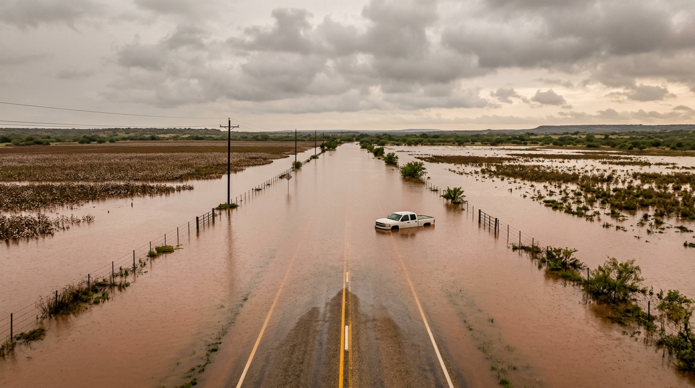
Massive rainfall triggered severe flash flooding across Uvalde County on July 14, 2026, resulting in a series of road closures and hazardous conditions for local travelers. The sudden surge of water transformed regional landscapes into temporary lakes, according to visual evidence captured by aerial observers. This weather event has notably impacted the movement of goods and people, leaving several vehicles trapped in rising waters and rendering major thoroughfares impassable for hours. Historically, South Texas has been susceptible to these rapid-onset floods due to the region's unique topography and the tendency for heavy summer downpours to saturate the dry ground faster than it can absorb moisture. Historically, Uvalde has served as a transition zone between the moisture of the Gulf and the arid regions of West Texas. This convergence often results in violent atmospheric shifts that dump several inches of rain in a matter of hours. The state has previously invested in flood mitigation through the Texas Water Development Board, but the sheer volume of water in these canyon-adjacent counties often overwhelms existing drainage infrastructure, leading to the dramatic scenes recently observed by drone operators.
Texas relevance
The flooding in Uvalde County highlights a recurring vulnerability for South Texas infrastructure and the local agricultural economy. Residents of the region frequently deal with the 'flashy' nature of the Nueces and Frio River basins, where dry creek beds can become raging torrents in a matter of minutes. As a critical hub for both transit and farming, the disruption in Uvalde creates ripple effects for regional supply chains and emergency response capabilities in rural districts of the Lone Star State. This specific geography, located southwest of San Antonio, means that flooding here can affect the broader Edwards Aquifer recharge zone, impacting the long-term water security and immediate physical safety of thousands of Texans.
Aerial Documentation of the Inundation
Recent drone operations over the flood-affected zones in Uvalde County have provided a comprehensive look at the scale of the disaster. The footage reveals wide swaths of land completely submerged under murky brown water, with typical boundary markers like fences and low-lying shrubs disappearing beneath the surface. This perspective has been vital for assessing which areas remain cut off from the primary highway systems, providing emergency management teams with real-time data that ground-level scouts simply cannot capture safely.
The aerial views specifically highlight the vulnerability of rural roads that crisscross the county. In many instances, the water has not merely covered the pavement but has deposited thick layers of silt and debris, which will require significant cleanup efforts before the paths are safe for civilian traffic. The visual data confirms that multiple vehicles were indeed caught in these flows, illustrating the speed at which the water rose and the relative lack of warning for drivers who were already on the road when the surges hit. These recordings serve as a grim evidence of the power of Texas weather systems during the peak of summer storm cycles.
Furthermore, the drone footage assists in identifying specific failure points in the local levee and drainage systems. By observing where the water overflows first, engineers can prioritize future stabilization projects. For a county like Uvalde, which balances a small-town economy with massive agricultural output, these visual records are more than just news; they are critical diagnostic tools for future urban and rural planning meant to protect the lives and livelihoods of the local citizenry.
Agricultural Infrastructure Under Water
Uvalde County is a significant contributor to the Texas agricultural sector, and the recent flooding has put local crops at risk. Drone surveys show that numerous fields have been turned into standing pools of water, which can lead to root rot and total crop loss if the drainage does not occur rapidly. The saturation of these fields prevents farmers from using heavy equipment to manage their land, potentially delaying harvests or planting cycles for the remainder of the 2026 season.
Beyond the crops themselves, the flooding threatens irrigation systems and storage facilities located in low-elevation areas. The infrastructure required to maintain these large-scale farming operations is often sensitive to water damage, and the cost of repairing submerged machinery or electric pump systems could pose a financial burden to the local farming community in the coming months. This economic hit is particularly painful for family-owned operations that lack the massive insurance buffers of corporate agricultural conglomerates.
The long-term impact on soil health is also a concern for Uvalde growers. While some flooding can deposit nutrient-rich sediment, the high-velocity flow characteristic of flash floods often strips away topsoil. This erosion can take years to recover from, fundamentally altering the productivity of what is normally some of the most fertile land in the South Texas Brush Country. Local cooperatives are expected to begin damage assessments as soon as the ground is dry enough to support foot traffic.
Transportation and Public Safety Concerns
Public safety officials have been forced to close various roads as the flooding made transit impossible. The primary danger during these events in Uvalde County is the 'low-water crossing,' a common feature in South Texas roads that becomes a lethal trap during heavy rains. Officials emphasize that even a few inches of moving water can exert enough force to displace a vehicle, leading to the stranding incidents observed in the recent footage. This has prompted local law enforcement to issue 'Turn Around, Don't Drown' reminders across social media.
The blocking of roads does more than just delay commuters; it restricts the ability of emergency services to reach isolated rural residences. With main arteries out of commission, the response time for medical or fire emergencies is significantly lengthened. In some cases, specialized high-water rescue vehicles or aircraft become the only way to facilitate medical evacuations, placing an additional strain on county resources and regional mutual aid agreements between Uvalde and neighboring jurisdictions like Zavala and Medina counties.
Recovery for the transportation sector will likely take weeks. Local TXDOT crews must inspect bridges for structural scouring and ensure that roadbeds haven't been hollowed out by the force of the undercurrents. For residents who rely on these routes for daily employment, the disruption represents not just an inconvenience, but a direct threat to their economic stability. The county's geography makes alternate routes scarce, often requiring detours of fifty miles or more when a single bridge is compromised.
Impact on Local Residents and Logistics
For the people living in Uvalde and the surrounding unincorporated areas, the flood is a major disruption to daily life. Residents in the path of the water have reported being unable to leave their properties, essentially becoming 'islands' until the water recedes. This isolation creates logistics hurdles for households needing supplies, particularly those located several miles from the nearest town center. Food and medicine deliveries are currently paused for several outlying rural neighborhoods until conditions improve.
The logistical impact extends to the transport of livestock and goods. Trucking routes that move cattle or produce through the county have been rerouted, adding time and fuel costs to regional commerce. As the water begins to move downstream, other areas within the Nueces River watershed must prepare for similar rises, making the monitoring of these flood crests a regional priority for South Texas. The movement of livestock is especially tricky, as getting animals to higher ground requires dry paths and functional trailers.
Local schools and community centers often serve as temporary shelters during these events, but the flooding can also make these hubs inaccessible. The psychological toll of these events on a community that has already faced significant challenges in recent years cannot be understated. Neighbors are currently relying on one another, using social media and radio to share information about which creek crossings are safe and which have been completely washed away by the torrents.
The Challenge of South Texas Topography
The geographic makeup of Uvalde County contributes significantly to the severity of these events. Situated on the edge of the Balcones Escarpment, the county features rocky soil and steep gradients in some areas that do not allow for slow infiltration of rainwater. Instead, the water collects rapidly and flows into the drainage basins, causing the flash flooding seen in the drone video. This 'flashiness' is a hallmark of the Hill Country's edge, where the land drops off toward the coastal plains.
This event serves as a reminder of the 'all or nothing' nature of Texas precipitation. Long periods of dry weather often precede these massive dumps of rain, which makes the ground even less receptive to water due to a phenomenon known as soil hydrophobicity. The transition from drought-like conditions to major flooding can happen in less than a day, leaving little time for large-scale mitigation efforts once the storms begin. The result is a cycle of water scarcity followed by water devastation.
Looking forward, state and local planners are forced to reconsider how they build in these zones. As weather patterns become more extreme, the traditional 100-year flood maps are being challenged by reality. Uvalde's experience is a microcosm of the challenges facing many rural Texas counties that must manage huge geographic areas with limited tax bases. Future investments in automated water-level sensors and solar-powered warning lights at low-water crossings are among the solutions being discussed to prevent future vehicle strandings.
Timeline and Recovery Expectations
The immediate timeline for recovery begins with the cessation of the primary rain bands, which allowed the river gauges to peak on the evening of July 14. Once the water crests and begins its slow march toward the Gulf of Mexico, local officials will initiate a formal damage assessment protocol. This involves ground crews inspecting every mile of county-maintained road. For many residents, the next 48 to 72 hours will be a waiting game as they wait for the 'washout' risks to subside so they can safely exit their properties.
Federal aid may be requested if the damage threshold meets the requirements for a disaster declaration. This would allow for low-interest loans for farmers and infrastructure grants for the county to rebuild bridges. However, such processes are notoriously slow, often taking months to move from application to funding. In the interim, the community relies on the Texas Division of Emergency Management and local non-profits to fill the gap in immediate needs like potable water and temporary housing for those whose homes were breached by the surge.
By the end of the week, the focus will likely shift from emergency response to restoration. This includes the removal of massive timber and debris piles that often accumulate against bridge pilings, creating 'dams' that can cause further flooding if another storm follows. The stability of the regional power grid in these rural areas is also a priority, as saturated ground can cause utility poles to lean or fall, leading to localized outages that further complicate the recovery effort for remote ranching outposts.
Source attribution
This story was reported using a public release from the Texas Storm Video (Google News). Keep TX Red rewrote the coverage independently and links to the official statement for verification.
Frequently Asked Questions
- What areas of Uvalde County are most affected by the flooding?
- Low-lying agricultural fields and rural roads, particularly those near river basins and low-water crossings, have seen the most significant inundation according to recent aerial footage. Areas near the Frio and Nueces rivers are at the highest risk for continued water accumulation.
- Are there any reported injuries from the stranded vehicles?
- While the footage shows vehicles trapped by water, the current reports focus on the structural and logistical impact of the flooding. Local authorities have conducted several high-water assists, and residents are urged to stay off the roads until official clearings are issued.
- How long will the roads remain blocked in Uvalde County?
- Road closures will depend on how quickly the floodwaters recede and the time required for crews to clear debris and inspect the pavement for washouts or structural damage. Major thoroughfares may open within 24-48 hours, while rural crossings could take longer.
- How can residents stay updated on road closures?
- Texans are encouraged to check the DriveTexas.org website or call 511 for the latest information on highway statuses. Local Uvalde County emergency management social media pages also provide real-time alerts for local county roads.
Official Sources
Take the next step
Browse the Newsroom →Read more about Keep Texas Red → Our full guide to what Keep Texas Red means and why Texans support it.
Related Articles



Get Texas updates delivered weekly.
Independent Texas reporting on politics, policy, and daily life. One email a week. Unsubscribe anytime.
Keep TX Red Newsroom
The Keep Texas Red Editorial Staff produces nonpartisan explainers, policy breakdowns, and educational resources to help Texans understand how their government works. All content is reviewed for accuracy and updated regularly.
About Keep TX Red →