Severe Weather Alert: Flash Floods and High Winds Forecast Across Texas Tonight
Texas Storm Chasers warn of flash flooding, large hail, and damaging winds as a major storm system moves through the state this evening.
Editorial disclaimer: Opinions and analysis on Keep TX Red are editorial content — not statements of fact. See our editorial standards.
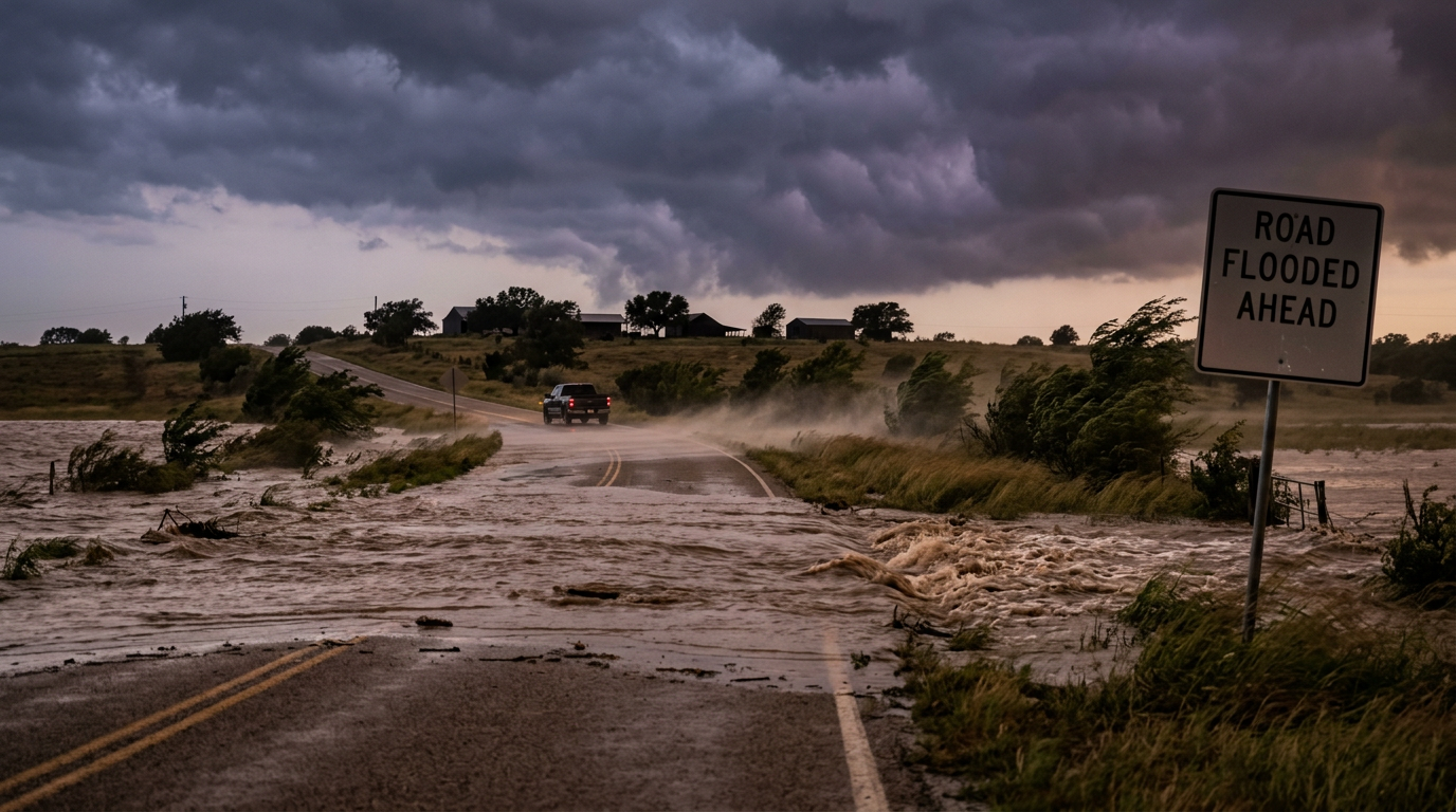
A significant weather system is tracking across Texas this evening, May 19, 2026, bringing threats of flash flooding, large hail, and destructive winds. According to the latest updates from Texas Storm Chasers, atmospheric conditions have aligned to create a high-impact event for several regions. Historically, spring in the Lone Star State is marked by these volatile transitions where Gulf moisture meets cold fronts, often resulting in rapid-onset flooding. This specific storm pattern follows a traditional meteorological track where instability builds over the dryline in West Texas before marching eastward into more humid air masses. Previous years have shown that even moderate rainfall on saturated ground can lead to life-threatening conditions in low-lying areas across Central and North Texas, where the terrain often funnels runoff into dangerous torrents. Experts note that these systems frequently gain strength after sunset, complicating visual identification of hazards and requiring residents to have multiple ways to receive warnings while they sleep.
Texas relevance
Residents throughout the state of Texas are under a heightened state of awareness as these storms pose a direct threat to property and public safety. Given the geography of Texas, particularly the 'Flash Flood Alley' corridor that runs through the Hill Country and into North Texas, tonight's forecast requires immediate attention from local homeowners and drivers. The state's infrastructure is frequently tested by these high-wind events, which can down power lines and cause widespread outages in major metropolitan hubs like Dallas, Austin, and San Antonio. The unique topography of the Balcones Escarpment within Texas serves to lift moist air rapidly, which can trigger the exact type of extreme rainfall rates expected tonight, making the region one of the most flood-prone areas in North America.
Understanding the Flash Flooding Risks
Flash flooding serves as one of the most dangerous elements of tonight's forecast. As the storm cells move through the state, they are expected to dump significant amounts of precipitation in short windows of time. This intensity often overwhelms local drainage systems and causes small creeks and streams to rise above their banks within minutes. The rapid nature of these events means that water levels can increase faster than emergency sirens or manual alerts can be deployed in some rural portions of the state.
Weather experts emphasize that the danger is not limited to active rainfall periods. Runoff can continue to collect in low-water crossings long after the primary storm front has passed, as water travels from higher elevations toward the coast. Texans are reminded to avoid driving through any standing water, as road surfaces may have already been washed away beneath the surface, making depth estimation impossible. The force of just six inches of fast-moving water is enough to knock an adult off their feet, while two feet of water can carry away most vehicles, including heavy SUVs and trucks typical of Texas roadways.
Damaging Winds and Property Protection
The forecast includes a significant threat of straight-line winds, which can often be as destructive as small tornadoes in their localized impact. These atmospheric gusts are capable of uprooting mature oaks, damaging residential roof structures, and turning unsecured outdoor furniture into dangerous projectiles. Professionals suggest that residents perform a quick sweep of their property to secure any loose items in their yards or on patios before the arrival of the storm front this evening.
Infrastructure vulnerabilities are also a primary concern when wind speeds reach the levels predicted for the current system. Power grids are frequently affected by falling limbs contacting lines, and utility companies across the state are likely on standby with mutual aid agreements ready to address surges in service interruptions. Early preparation and ensuring that mobile devices are fully charged is the most effective way for residents to mitigate the frustration of potential outages prior to the onset of severe weather.
Historical Context of Texas Spring Storms
Texas has a long and documented history with severe spring weather, often serving as the primary battleground for clashing air masses. The month of May is statistically the wettest month for many parts of the state, fueled by the collision of dry air from the Rockies and moist air from the Gulf of Mexico. This interaction creates the instability necessary for Supercell development, which can produce the large hail and high winds forecasted for tonight.
Looking back at previous decades, many of the state’s most memorable weather disasters occurred during this exact window. By understanding this historical precedent, state officials and meteorologists can better predict the movement of these systems. However, each storm carries its own unique signature, and the high-resolution modeling used by today’s chasers allows for more precise ground-level warnings than were available in previous generations, potentially saving lives through increased lead times.
The Impact of Large Hail on Agriculture and Housing
Hail remains a distinct possibility with tonight's atmospheric profile, which features strong updrafts capable of suspending ice pellets until they grow to significant sizes. Disruption in the upper atmosphere allows for the formation of stones that can reach diameters capable of shattering windshields and denting vehicle bodies. For Texas, which leads the nation in many hail-related insurance claims, this part of the storm brings a specific set of financial risks that impact the state's economy long after the clouds clear.
Vehicle owners without garage access are encouraged to seek temporary shelter for their automobiles in covered parking structures if available. Historically, these storms can move unpredictably, meaning hail may fall in localized pockets even if the broader regional forecast seems relatively calm. Vigilance regarding local radar updates is essential for those in the potential path of the most intense cells, as a difference of just a few miles can be the determining factor between a minor rain event and a total loss of property due to ice damage.
Emergency Preparedness and Communication Strategies
Reliable communication is the cornerstone of safety during a severe weather event in Texas. Using battery-powered weather radios or specialized mobile apps ensures that families receive alerts even if local cell towers or internet services are compromised by wind or lightning strikes. Having a pre-established plan for where to shelter within the home—typically a small interior room—is a critical step for all households to take before the sun goes down and visibility decreases.
Emergency management officials suggest that families keep a fundamental kit ready, including flashlights, fresh batteries, and a basic first-aid kit. Because these storms are moving through during the evening and overnight hours, visibility will be severely limited, making it harder to spot rising water or debris on the roads. Remaining indoors until the alerts are officially cleared is the recommended course of action for all non-emergency personnel to ensure that roads remain clear for first responders.
What Changes Next: Future Weather Outlook
Following the passage of tonight’s storm system, the atmospheric profile over Texas is expected to stabilize temporarily as a minor cool front settles over the region. However, the pattern of instability is likely to persist through the end of the week as Gulf moisture quickly returns to the state. This means that while tonight is the immediate focus, residents should remain prepared for a recurring cycle of storm development throughout the remainder of the month.
State agencies will be monitoring the soil saturation levels closely after tonight's rain. If the ground remains heavily saturated, future storms with even lower rainfall totals could trigger more frequent flooding events. This cumulative effect is often what leads to the most significant river flooding in the eastern half of the state. Consequently, the mitigation efforts and emergency responses initiated tonight will likely serve as a blueprint for the remainder of this active spring season.
Analysis
While the primary focus remains on immediate safety, the frequency of these high-intensity systems in 2026 continues to demonstrate the need for robust state emergency management protocols and localized infrastructure investment. The rapid development of these storms often leaves little time for reactive measures, highlighting the importance of the early warning systems provided by groups like the Texas Storm Chasers. For the state, the economic impact of hail damage alone remains a significant concern for the insurance industry and agricultural sectors alike, often resulting in billions of dollars in claims annually. This ongoing vulnerability suggests that Texas will continue to prioritize weather resilience in its long-term urban planning and power grid hardening initiatives.
Source attribution
This story was reported using a public release from the Texas Storm Video (Google News). Keep TX Red rewrote the coverage independently and links to the official statement for verification.
Frequently Asked Questions
- What should I do if I am caught driving during a flash flood?
- The safest action is to 'Turn Around, Don't Drown.' Never attempt to drive through water on a road, even if it appears shallow. If your vehicle stalls in rapidly rising water, abandon it immediately and seek higher ground on foot if it is safe to do so. Nighttime driving is particularly dangerous as it is difficult to see the depth of the water.
- How can I protect my property from high winds?
- Before the storm arrives, secure all outdoor furniture, trash cans, and tools. Ensure that your vehicles are parked away from large trees or overhanging branches that could fall during high-wind gusts. Close all interior doors in the house to help stabilize the pressure if a window is broken.
- Where is the safest place to be during a severe thunderstorm?
- The best place is an interior room on the lowest floor of a sturdy building, away from windows and exterior walls. A bathroom, closet, or hallway is often the most protected area. Avoid using corded electronics during the peak of lightning activity.
Official Sources
Take the next step
Browse the Newsroom →Read more about Keep Texas Red → Our full guide to what Keep Texas Red means and why Texans support it.
Related Articles



Get Texas updates delivered weekly.
Independent Texas reporting on politics, policy, and daily life. One email a week. Unsubscribe anytime.
Keep TX Red Newsroom
The Keep Texas Red Editorial Staff produces nonpartisan explainers, policy breakdowns, and educational resources to help Texans understand how their government works. All content is reviewed for accuracy and updated regularly.
About Keep TX Red →